


Mamburao was originally settled by the Moro people and was one of their strongholds in the island of Mindoro. The settlement was the first one in Mindoro to be plundered by the Spaniards. Hearing that it was a rich town, the Spanish and their Pintado allies attacked and captured the population. The wealthy among their captives were then allowed to ransom themselves free. With their superior weapons and knowledge of war strategies used in their just concluded Reconquista, they utilised this method all around the islands, and by this the Spanish earned their gold.
On January 1, 1560, wanting more, Miguel López de Legazpi sent a fleet of 15 boats from Panay, led by his grandson Juan de Salcedo, to conquer the Moro town. Another expedition was sent to Mamburao, led by Salcedo and Martin de Goiti, with the intent of establishing Spanish presence in Mindoro.
Catholicism was propagated in Mamburao and the town was placed under the third convent district based in Cavite. Mamburao was subjected to attack by the Mindanao Moro, guided by its former Mamburao inhabitants who wanted to claim their lands and have a prosperous life there between the 17th and 18th centuries. Mamburao, supported by its population, was even made into a sea haven by the Moros, who used it as base of their sea attacks against Friar induced settlements on coastal towns in Mindoro, Luzon and Visayas.
In the late 19th century, encouraged by Spanish authorities promising them rich lands to till, with weapons but in exchange for working as its ready foot soldiers on quick notice, Mamburao then saw an influx of Ilocano and Tagalog immigrants.
Near the end of the Spanish colonial period in the Philippines, the settlement of Sablayan was incorporated to Mamburao as a barrio. In 1905, Paluan and Abra de Ilog were likewise incorporated under Act 1280. Abra de Ilog, Paluan and Sablayan were later carved out from Mamburao as separate municipalities. Another barrio of Mamburao, Santa Cruz, was also made into a separate municipality, in 1949.
Mamburao was designated as the capital of Occidental Mindoro when the island province of Mindoro was divided into two separate provinces on June 13, 1950: Oriental and Occidental Mindoro. San Jose was the temporary capital until January 1, 1951.
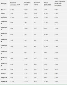
Mamburao is politically subdivided into 15 barangays. Eight barangays are found in the population created under P.D. 86 and seven are outside the poblacion area as shown in the following table.
Visit the Mamburao Official Website for more information and updates.

References:
- https://en.wikipedia.org/wiki/Mamburao
- https://www.philatlas.com/luzon/mimaropa/occidental-mindoro/mamburao.html