

ECONOMIC PROFILE
SOCIO ECONOMIC PROFILE

Basic Information:
Income Class: 2nd
Population (CY 2020): 525, 354
No. of Households (CY 2015): 111, 714
Land Area (in sq. km): 5, 879.85
Website: https://occidentalmindoro.gov.ph/
Hazards:
Earthquake/Ground-shaking
Flood
Rain-induces Landslide
Storm surge/Tsunami
Typhoon
Ecosystems:
Agricultural
Coastal Marine
Forest
Freshwater
Urban
Economic Activity:
Agriculture
Commercial and service centers
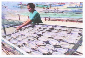
Fisheries
Mining and quarrying
Tourism
GEOGRAPHICAL LOCATION
Mindoro Island, the seventh-largest island in the Philippines, is contained in the quadrangle bounded by 12° 9′ north latitude, 120°01′ east longtitude and 12°54′ north latitude, 121°15′ east longtitude. Occidental MIndoro is one of the two provinces comprising Mindoro Island. It is located 45 km. south of batangas and North of Visayas. The entire eastern portion of the province is bounded by Oriental Mindoro and western portion by the Apo East Passage. On the north, it is bounded by the Calavite and Verde Island Passage, and on the south, by Minndoro Strait. The southernmost tip of Occidental Mindoro lies in Sibuyan Sea. Like most of the provinces in the Philippines, the lack of technical description defining the boundaries of the province causes territorial dispute with its neighboring province, Oriental Mindoro.
LAND AREA
Occidental Mindoro, with a land area of approximately 5, 879.85 sq. kilometers, is the 17th largest province in the country, and the 2nd largest province in the MIMAROPA Region. The province comprises 12.5 percent of the entire area of the Southern Tagalog Region and 21.41 percent of the MIMAROPA Region. The municipality of Sablayan, with an area of 2, 188.00 sq. km. is the largest municipality, occupies 681 sq. km. or about 11.59 percent of the province’s landmass. The Municipality of Lubang, with a land area of 113.10 sq. km. is the smallest, occupying about 1.92 percent of the province’s land area.
Table 1. Land Area by Municipalities with percent store, 2010
| Municipalities by Cluster Area | Area (km²) | Area (sq. km) % Share |
|---|---|---|
| Looc | 132.3 | 2.25 |
| Lubang | 113.1 | 1.92 |
| ISLAND GROWTH Corridor | 245.4 | 4.17 |
| Mamburao | 297.6 | 5.06 |
| Abra de Ilog | 533.7 | 9.08 |
| Paluan | 564.5 | 9.6 |
| Sta. Cruz | 681.4 | 11.59 |
| MAPSA Growth Corridor | 2, 077.20 | 35.33 |
| Sablayan | 1, 188.80 | 37.23 |
| SABLAYAN Growth Corridor | 2, 188.80 | 37.23 |
| San Jose | 446.7 | 7.6 |
| Magsaysay | 296.75 | 5.05 |
| Rizal | 241.5 | 4.12 |
| Calintaan | 382.5 | 6.5 |
| SAMARICA Growth Corridor | 1, 368.45 | 23.27 |
| OCCIDENTAL MINDORO | 5, 879.85 | 100 |
POLITICAL SUBDIVISION
Occidental Mindoro, a second-class province, and a lone congressional district is composed of 11 municipalities, nine (9) of which are in the maniland and two (2) island municipalities. It has 164 barangays: 42 urban and 122 rural. The province also consists of four (4) growth areas such as the Island Growth Corridor which includes the municipalities of Lubang and Looc; MAPSA Growth Corridor comprised of the municipalities of Mamburao, Abra de Ilog, Paluan, and Sta. Cruz, Sablayan Growth Corridor; and lastly SAMARICA Growth Corridor which covers the municipalities of San Jose, Magsaysay, Rizal, and Calintaan. The municipalities of Lubang and Looc are in Lubang Island situated at the northern tip of the province. First class municipalities include Sablayan, San Jose, and Sta. Cruz. Mamburao and Abra de Ilog second-class municipalities. The remaining four municipalities are 3rd class, namely: Calintaan, Magsaysay, Paluan, and Rizal, while Lubang and Looc belong to the 4th class and 5th class, respectively.
Table 2. Number of barangays per municipality.
| Municipalities by Cluster Area | Number of Barangays | |
|---|---|---|
| Rural | Urban | |
| Looc | 6 | 3 |
| Lubang | 10 | 6 |
| ISLAND GROWTH Corridor | ||
| Mamburao | 10 | 5 |
| Abra de Ilog | 9 | 5 |
| Paluan | 8 | 4 |
| Sta. Cruz | 8 | 3 |
| MAPSA Growth Corridor | ||
| Sablayan | 19 | 3 |
| SABLAYAN Growth Corridor | ||
| San Jose | 26 | 13 |
| Magsaysay | 11 | 1 |
| Rizal | 9 | 2 |
| Calintaan | 6 | 1 |
| SAMARICA Growth Corridor | ||
| OCCIDENTAL MINDORO | ||
LAND AREA BY MUNICIPALITY
Table 3 shows the land area by municipality. As shown also, Sablayan has the largest land area with 210, 440.11 ha². In fact, it is the largest municipality in the Philippines. Contrary, the municipality of Lubang has the smallest land area with 12, 546.88 ha².
However, as clearly stated in the table, data are not authoritative because of the on-going boundary disputes between municipalities.
Table 2. Land area by municipality.
| Municipality | Area (ha²) | Remarks |
|---|---|---|
| Abra de Ilog | 60,233.63 | Data not authoritative due to on-going boundary dispute/settlement between province/municipality. |
| Calintaan | 29,897.29 | |
| Looc | 12,942.25 | |
| Lubang | 12,546.88 | |
| Magsaysay | 26,035.34 | |
| Mamburao | 32,099.39 | |
| Paluan | 52,991.32 | |
| Rizal | 30,388.24 | |
| Sablayan | 210,440.11 | |
| San Jose | 61,085.32 | |
| Sta. Cruz | 68,902.71 | |
| Occidental Mindoro | 597,562.48 |
POPULATION
Size and Distribution
For four (4) cnsecutive censal years, in terms of population, among the municipalities, San Jose ranked 1st and Sablayan ranked 2nd, both being the most progressive towns in terms of size and growth rate due to high fertility rate and migration from other municipalities caused by economically productive population of these two towns. Mamburao, the capital town, ranked 3rd maintaining its rank for 3 consecutive censal years. The municiplaities of Paluan and Looc, consistently got the lowest ranl with 10th and 11th respectively.
Density and Urbanization
With the country’s total land area of 294,554 square kilometers and the 2010 total population of 93,337,852, the crude density index of the Philippined was estimated at 313 persons per square lilomters, more or less 20 percent higher that that of the 2000 level of 260 persons per square kilometer. In census year 2010, the population density of the rigion was 100 persons per square kilometer, an increase of 16 persons per square kilometers from 2000 and 213 points lower than the national figure.
In terms of its share to the total population, the region’s 2,963,360 accounted for nearly 3 percent. The region had an increasing growth rate as seen from the 2007 to 2015 is 83 persons per square kilometer, an increase of 11 persons per square kilometer from the 2007 figure of 72 persons per square kilometer. Occidental Mindoro’s population density remains to be the 2nd lowest among the province in MIMAROPA with Marinduque having the highest population density with 244 persons per square kilometer.
The most densely populated municipality is San Jose of SAMARICA Growth Corridor, whose 321 persons per square kilometer where almost 4 times higher that the province’s density of 83 persons per square kilometer. Followed by the municipality of Lubang with a density level of 166, Rizal with 158 and Mamburao with 144 persons per square kilometer.
The high population dennsity of San Jose and Mamburao is attributed to its being the commercial and capital center of the province where most of the residents converged. For Lubang and Rozal, the high population density is primarily due to its high population and relatively smaller land area.
In contrast, the municipalities od Calintaan, Looc, Abra de Ilog, Sta. Cruz, Sablayan, and Paluan had density levels lower than the province’s level at 78, 76, 55, 38, and 28 persons per square kilometer, respectively.
INCOME CLASS
Occidental Mindoro is a second-class province and a lone congressional district. The province’s income sources are the following:
| Income Source | 2018 | 2019 |
|---|---|---|
| Local Source | 73,697,188.69 | 95,618,497 |
| IRA (Internal Revenue) | 1,295,139,753.40 | 1,411,617,228.00 |
| TOTAL | 1,368,837,188.69 | 1,507,235,725.00 |
POVERTY INCIDENCE
Poverty Threshold is the minimum income required to meet basic needs and other non-food requirements such as clothing, housing, transportation , health, and education expenses. While Food threshold is the minimum income required to meet basic needs and satisfy the nutirtional requirements set by the Food and Nutrition Research Institute (FNRI).
On the other hand, poverty is the proportion of the population and the families whose per capita income is below the poverty threshold. Subsidence incidence is the proportion of the population with per capita income less than the per capita threshold.
| Income Source | 2018 | 2019 |
|---|---|---|
| Local Source | 73,697,188.69 | 95,618,497 |
| IRA (Internal Revenue) | 1,295,139,753.40 | 1,411,617,228.00 |
| TOTAL | 1,368,837,188.69 | 1,507,235,725.00 |
POVERTY THRESHOLD
| Province | Annual Per Capita Poverty Threshold (in Pesos) | Poverty Incidence (Families) | Poverty Incidence among Population (%) | ||||||
|---|---|---|---|---|---|---|---|---|---|
| Occidental Mindoro | 2012 | 2015 | 2018 | 2012 | 2015 | 2018 | 2012 | 2015 | 2018 |
| 17,412 | 19,994 | 10,577 | 24,203 | 31.07 | 22 | 38.1 | 41.2 | 29 | |
FOOD THRESHOLD
| Province | Annual Per Capita Poverty Threshold (in Pesos) | Food Incidence (Families) | Subsidence Incidence among Population (%) | ||||||
|---|---|---|---|---|---|---|---|---|---|
| Occidental Mindoro | 2012 | 2015 | 2018 | 2012 | 2015 | 2018 | 2012 | 2015 | 2018 |
| 12,103 | 13,901 | 7,375 | 13.6 | 15.8 | 8.1 | 20.1 | 23 | 11.1 | |